Difference between revisions of "orlando-toll-roads-toll-map"
| (14 intermediate revisions by 2 users not shown) | |||
| Line 7: | Line 7: | ||
__TOC__ | __TOC__ | ||
<div class="shadowCard"> | <div class="shadowCard"> | ||
| − | Orlando | + | Central Florida near Orlando has an extensive network of toll facilities including [https://tollguru.com/toll-wiki/disney-world-florida-toll toll roads leading to the Walt Disney World]. Below is the toll map showing toll plazas locations on the Central Florida toll roads near Orlando. |
<div style="text-align: center;"> | <div style="text-align: center;"> | ||
| − | <html><figure class="aligncenter size-full is-resized"><img alt="Map of Central Florida toll booth locations near Orlando including the roads of Florida Turnpike" class="wp-image-6780" height="415" loading="lazy" sizes="(max-width: 560px) 100vw, 563px" src="https:// | + | <html><figure class="aligncenter size-full is-resized"><img alt="Map of Central Florida toll booth locations near Orlando including the roads of Florida Turnpike" class="wp-image-6780" height="415" loading="lazy" sizes="(max-width: 560px) 100vw, 563px" src="https://cms.ec2.mapup.ai/wp-content/uploads/2020/12/Central-Florida-near-Orlando-Toll-Map.jpg" srcset="https://cms.ec2.mapup.ai/wp-content/uploads/2020/12/Central-Florida-near-Orlando-Toll-Map.jpg 1784w, https://cms.ec2.mapup.ai/wp-content/uploads/2020/12/Central-Florida-near-Orlando-Toll-Map-640x472.jpg 640w, https://cms.ec2.mapup.ai/wp-content/uploads/2020/12/Central-Florida-near-Orlando-Toll-Map-1280x945.jpg 1280w, https://cms.ec2.mapup.ai/wp-content/uploads/2020/12/Central-Florida-near-Orlando-Toll-Map-768x567.jpg 768w, https://cms.ec2.mapup.ai/wp-content/uploads/2020/12/Central-Florida-near-Orlando-Toll-Map-1536x1134.jpg 1536w" width="560"/></figure></html> |
</div> | </div> | ||
| Line 16: | Line 16: | ||
You'll come across the following eight stretches of toll roads in the Central Florida: | You'll come across the following eight stretches of toll roads in the Central Florida: | ||
<div class="row"> | <div class="row"> | ||
| − | + | <div class="col-lg-6"> | |
*Turnpike – Northern Coin System | *Turnpike – Northern Coin System | ||
*Martin Andersen Beachline West Expressway | *Martin Andersen Beachline West Expressway | ||
| Line 22: | Line 22: | ||
*Southern Connector Extension | *Southern Connector Extension | ||
</div> | </div> | ||
| − | + | <div class="col-lg-6"> | |
*Daniel Webster Western Beltway, Part C | *Daniel Webster Western Beltway, Part C | ||
*Wekiva Parkway | *Wekiva Parkway | ||
| Line 33: | Line 33: | ||
Use [https://tollguru.com/orlando-toll-calculator Orlando Toll Calculator] to calculate toll and gas costs to travel across Central Florida and other [https://tollguru.com/toll-wiki/florida-toll-roads-bridges-express-lanes-expressways-sunpass toll facilities of Florida]. | Use [https://tollguru.com/orlando-toll-calculator Orlando Toll Calculator] to calculate toll and gas costs to travel across Central Florida and other [https://tollguru.com/toll-wiki/florida-toll-roads-bridges-express-lanes-expressways-sunpass toll facilities of Florida]. | ||
| − | < | + | <html> |
<div style="text-align: center;"> | <div style="text-align: center;"> | ||
| − | <a href="https://tollguru.com/orlando-toll-calculator"><button | + | <a href="https://tollguru.com/orlando-toll-calculator"><button class="custom-button button-orange" type="button">Orlando Toll Calculator</button></a> |
</div> | </div> | ||
</html> | </html> | ||
| − | |||
</div><div class="shadowCard"> | </div><div class="shadowCard"> | ||
== How do I pay Central Florida tolls == | == How do I pay Central Florida tolls == | ||
| − | ''main article: [https://tollguru.com/toll-wiki/pay-toll-florida How to Pay Toll in Florida] | + | ''main article: [https://tollguru.com/toll-wiki/pay-toll-florida How to Pay Toll in Florida]'' |
| + | |||
For all the toll roads under Central Florida Expressway Authority (CFX)<ref>[https://www.cfxway.com/ Central Florida Expressway Authority (CFX)]</ref>, you can pay Central Florida tolls with: | For all the toll roads under Central Florida Expressway Authority (CFX)<ref>[https://www.cfxway.com/ Central Florida Expressway Authority (CFX)]</ref>, you can pay Central Florida tolls with: | ||
| Line 60: | Line 60: | ||
<html><table> | <html><table> | ||
| − | + | <caption>FL 417 toll rates for Motorcycle & 2 Axles vehicles on mainline plazas</caption> | |
| − | + | <tr> | |
| − | + | <th>Mainline Toll Plaza</th> | |
| − | + | <th>E-Pass</th> | |
| − | + | <th>Cash</th> | |
| − | + | <th>Pay By Plate</th> | |
| − | + | </tr> | |
| − | + | <tr> | |
| − | + | <td>John Young</td> | |
| − | + | <td>$1.47</td> | |
| − | + | <td>$1.75</td> | |
| − | + | <td>$2.94</td> | |
| − | + | </tr> | |
| − | + | <tr> | |
| − | + | <td>Boggy Creek</td> | |
| − | + | <td>$1.47</td> | |
| − | + | <td>$1.75</td> | |
| − | + | <td>$2.94</td> | |
| − | + | </tr> | |
| − | + | <tr> | |
| − | + | <td>Curry Ford</td> | |
| − | + | <td> $0.88</td> | |
| − | + | <td>$1.00</td> | |
| − | + | <td> $1.76</td> | |
| − | + | </tr> | |
| − | + | <tr> | |
| − | + | <td>University </td> | |
| − | + | <td>$0.88</td> | |
| − | + | <td>$1.00</td> | |
| − | + | <td> $1.76</td> | |
| − | + | </tr> | |
| − | |||
| − | |||
| − | |||
| − | |||
| − | |||
| − | |||
| − | |||
</table></html> | </table></html> | ||
| Line 106: | Line 99: | ||
== Florida Turnpike - Northern Coin System == | == Florida Turnpike - Northern Coin System == | ||
<div style="text-align: center;"> | <div style="text-align: center;"> | ||
| − | <html><figure class="aligncenter size-full is-resized"><img alt="Map of toll booths on Florida Turnpike-Northern Coin System including I-4, I-75 and I-95" class="wp-image-6789" height="483" loading="lazy" sizes="(max-width: 560px) 100vw, 563px" src="https:// | + | <html><figure class="aligncenter size-full is-resized"><img alt="Map of toll booths on Florida Turnpike-Northern Coin System including I-4, I-75 and I-95" class="wp-image-6789" height="483" loading="lazy" sizes="(max-width: 560px) 100vw, 563px" src="https://cms.ec2.mapup.ai/wp-content/uploads/2020/12/Florida-Turnpike-Northern-Coin-System-Toll-Map.jpg" srcset="https://cms.ec2.mapup.ai/wp-content/uploads/2020/12/Florida-Turnpike-Northern-Coin-System-Toll-Map.jpg 1786w, https://cms.ec2.mapup.ai/wp-content/uploads/2020/12/Florida-Turnpike-Northern-Coin-System-Toll-Map-583x500.jpg 583w, https://cms.ec2.mapup.ai/wp-content/uploads/2020/12/Florida-Turnpike-Northern-Coin-System-Toll-Map-1194x1024.jpg 1194w, https://cms.ec2.mapup.ai/wp-content/uploads/2020/12/Florida-Turnpike-Northern-Coin-System-Toll-Map-768x659.jpg 768w, https://cms.ec2.mapup.ai/wp-content/uploads/2020/12/Florida-Turnpike-Northern-Coin-System-Toll-Map-1536x1318.jpg 1536w" width="560"/></figure></html> |
</div> | </div> | ||
| Line 114: | Line 107: | ||
== Martin Andersen Beachline Expressway == | == Martin Andersen Beachline Expressway == | ||
<div style="text-align: center;"> | <div style="text-align: center;"> | ||
| − | <html><figure class="aligncenter size-large is-resized"><img alt="Toll booth locations of Florida 528 or Martin B. Andersen Beachline Expressway Toll Plazas in both east and west side" class="wp-image-6791" height="300" loading="lazy" src="https:// | + | <html><figure class="aligncenter size-large is-resized"><img alt="Toll booth locations of Florida 528 or Martin B. Andersen Beachline Expressway Toll Plazas in both east and west side" class="wp-image-6791" height="300" loading="lazy" src="https://cms.ec2.mapup.ai/wp-content/uploads/2020/12/Florida-528-Beachline-Expressway-Toll-Map-1-1280x672.jpg" width="560"/></figure></html> |
</div> | </div> | ||
=== Martin Andersen Beachline West Expressway === | === Martin Andersen Beachline West Expressway === | ||
| Line 128: | Line 121: | ||
== Seminole Expressway == | == Seminole Expressway == | ||
<div style="text-align: center;"> | <div style="text-align: center;"> | ||
| − | <html><figure class="aligncenter size-full is-resized"><img alt="Toll booth locations on Florida 417 or Seminole Expressway which extends from the Seminole County line to Interstate 4" class="wp-image-6792" height="916" loading="lazy" sizes="(max-width: 400px) 100vw, 563px" src="https:// | + | <html><figure class="aligncenter size-full is-resized"><img alt="Toll booth locations on Florida 417 or Seminole Expressway which extends from the Seminole County line to Interstate 4" class="wp-image-6792" height="916" loading="lazy" sizes="(max-width: 400px) 100vw, 563px" src="https://cms.ec2.mapup.ai/wp-content/uploads/2020/12/Florida-417-Seminole-Expressway-Toll-Map.jpg" srcset="https://cms.ec2.mapup.ai/wp-content/uploads/2020/12/Florida-417-Seminole-Expressway-Toll-Map.jpg 1126w, https://cms.ec2.mapup.ai/wp-content/uploads/2020/12/Florida-417-Seminole-Expressway-Toll-Map-307x500.jpg 307w, https://cms.ec2.mapup.ai/wp-content/uploads/2020/12/Florida-417-Seminole-Expressway-Toll-Map-629x1024.jpg 629w, https://cms.ec2.mapup.ai/wp-content/uploads/2020/12/Florida-417-Seminole-Expressway-Toll-Map-768x1250.jpg 768w, https://cms.ec2.mapup.ai/wp-content/uploads/2020/12/Florida-417-Seminole-Expressway-Toll-Map-944x1536.jpg 944w" width="400"/></figure></html> |
</div> | </div> | ||
The Seminole Expressway is State Road 417 is a 55-mile toll road operated by CFX and Florida’s Turnpike Enterprise in the Orlando region that runs from north to south. It extends from the Seminole County line to Interstate 4 in Sandford. | The Seminole Expressway is State Road 417 is a 55-mile toll road operated by CFX and Florida’s Turnpike Enterprise in the Orlando region that runs from north to south. It extends from the Seminole County line to Interstate 4 in Sandford. | ||
| Line 136: | Line 129: | ||
== Southern Connector Extension == | == Southern Connector Extension == | ||
<div style="text-align: center;"> | <div style="text-align: center;"> | ||
| − | <html><figure class="aligncenter size-full is-resized"><img alt="Toll booth locations on Southern Connector Extension or Southern end of the Central Florida or Eastern Belt of Orlando" class="wp-image-6793" height="310" loading="lazy" sizes="(max-width: 560px) 100vw, 563px" src="https:// | + | <html><figure class="aligncenter size-full is-resized"><img alt="Toll booth locations on Southern Connector Extension or Southern end of the Central Florida or Eastern Belt of Orlando" class="wp-image-6793" height="310" loading="lazy" sizes="(max-width: 560px) 100vw, 563px" src="https://cms.ec2.mapup.ai/wp-content/uploads/2020/12/Southern-Connector-Extension-Toll-Map.jpg" srcset="https://cms.ec2.mapup.ai/wp-content/uploads/2020/12/Southern-Connector-Extension-Toll-Map.jpg 1348w, https://cms.ec2.mapup.ai/wp-content/uploads/2020/12/Southern-Connector-Extension-Toll-Map-640x351.jpg 640w, https://cms.ec2.mapup.ai/wp-content/uploads/2020/12/Southern-Connector-Extension-Toll-Map-1280x703.jpg 1280w, https://cms.ec2.mapup.ai/wp-content/uploads/2020/12/Southern-Connector-Extension-Toll-Map-768x422.jpg 768w" width="560"/></figure></html> |
</div> | </div> | ||
The Southern Connector Extension of the Central Florida GreeneWay is a section of State Road 417. It is also referred to as the southern end of the Central Florida GreeneWay. It forms the eastern belt around the city of Orlando. So although it runs north-south throughout its route; it also runs east-east between Celebration and Country Road 15. After Country road 15, it runs north-south through the rest of its route. | The Southern Connector Extension of the Central Florida GreeneWay is a section of State Road 417. It is also referred to as the southern end of the Central Florida GreeneWay. It forms the eastern belt around the city of Orlando. So although it runs north-south throughout its route; it also runs east-east between Celebration and Country Road 15. After Country road 15, it runs north-south through the rest of its route. | ||
| Line 143: | Line 136: | ||
== Daniel Webster Western Beltway - Part C == | == Daniel Webster Western Beltway - Part C == | ||
<div style="text-align: center;"> | <div style="text-align: center;"> | ||
| − | <html><figure class="aligncenter size-full is-resized"><img alt="Toll booth locations of Florida 429 or Daniel Webster Western Beltway from Apopka south to Osceola County" class="wp-image-6794" height="849" loading="lazy" sizes="(max-width: 400px) 100vw, 563px" src="https:// | + | <html><figure class="aligncenter size-full is-resized"><img alt="Toll booth locations of Florida 429 or Daniel Webster Western Beltway from Apopka south to Osceola County" class="wp-image-6794" height="849" loading="lazy" sizes="(max-width: 400px) 100vw, 563px" src="https://cms.ec2.mapup.ai/wp-content/uploads/2020/12/Florida-429-Daniel-Webster-Western-Beltway-Toll-Map.jpg" srcset="https://cms.ec2.mapup.ai/wp-content/uploads/2020/12/Florida-429-Daniel-Webster-Western-Beltway-Toll-Map.jpg 1126w, https://cms.ec2.mapup.ai/wp-content/uploads/2020/12/Florida-429-Daniel-Webster-Western-Beltway-Toll-Map-332x500.jpg 332w, https://cms.ec2.mapup.ai/wp-content/uploads/2020/12/Florida-429-Daniel-Webster-Western-Beltway-Toll-Map-679x1024.jpg 679w, https://cms.ec2.mapup.ai/wp-content/uploads/2020/12/Florida-429-Daniel-Webster-Western-Beltway-Toll-Map-768x1158.jpg 768w, https://cms.ec2.mapup.ai/wp-content/uploads/2020/12/Florida-429-Daniel-Webster-Western-Beltway-Toll-Map-1019x1536.jpg 1019w" width="400"/></figure></html> |
</div> | </div> | ||
Daniel Webster Western Beltway or otherwise the State Road 429 extends from Highway 441 in Apopka south to Interstate 4 in Osceola County. It provides West Orange and Osceola counties with an alternate route, instead of the otherwise heavily travelled Interstate-4. | Daniel Webster Western Beltway or otherwise the State Road 429 extends from Highway 441 in Apopka south to Interstate 4 in Osceola County. It provides West Orange and Osceola counties with an alternate route, instead of the otherwise heavily travelled Interstate-4. | ||
| Line 151: | Line 144: | ||
== Wekiva Parkway == | == Wekiva Parkway == | ||
<div style="text-align: center;"> | <div style="text-align: center;"> | ||
| − | <html><figure class="aligncenter is-resized"><img alt="Toll booth locations of Wekiva Parkway part of Central Florida Beltway encircling Metro Orlando" class="wp-image-6795" height="379" loading="lazy" sizes="(max-width: 560px) 100vw, 563px" src="https:// | + | <html><figure class="aligncenter is-resized"><img alt="Toll booth locations of Wekiva Parkway part of Central Florida Beltway encircling Metro Orlando" class="wp-image-6795" height="379" loading="lazy" sizes="(max-width: 560px) 100vw, 563px" src="https://cms.ec2.mapup.ai/wp-content/uploads/2020/12/Wekiva-Parkway-Toll-Map.jpg" srcset="https://cms.ec2.mapup.ai/wp-content/uploads/2020/12/Wekiva-Parkway-Toll-Map.jpg 1126w, https://cms.ec2.mapup.ai/wp-content/uploads/2020/12/Wekiva-Parkway-Toll-Map-640x432.jpg 640w, https://cms.ec2.mapup.ai/wp-content/uploads/2020/12/Wekiva-Parkway-Toll-Map-768x518.jpg 768w" width="560"/></figure></html> |
</div> | </div> | ||
| Line 159: | Line 152: | ||
== Osceola Parkway == | == Osceola Parkway == | ||
<div style="text-align: center;"> | <div style="text-align: center;"> | ||
| − | <html><figure class="aligncenter size-full"><img alt="Toll booth locations of Osceola Parkway or CR 522 connecting Disney World resort area near Kissimmee and Buena Ventura" class="wp-image-7028" height="574" loading="lazy" sizes="(max-width: 560px) 100vw, 563px" src="https:// | + | <html><figure class="aligncenter size-full"><img alt="Toll booth locations of Osceola Parkway or CR 522 connecting Disney World resort area near Kissimmee and Buena Ventura" class="wp-image-7028" height="574" loading="lazy" sizes="(max-width: 560px) 100vw, 563px" src="https://cms.ec2.mapup.ai/wp-content/uploads/2021/01/Osceola-Parkway-CR-522-Toll-Map.jpg" srcset="https://cms.ec2.mapup.ai/wp-content/uploads/2021/01/Osceola-Parkway-CR-522-Toll-Map.jpg 563w, https://cms.ec2.mapup.ai/wp-content/uploads/2021/01/Osceola-Parkway-CR-522-Toll-Map-490x500.jpg 490w" width="560"/></figure></html> |
</div> | </div> | ||
The Osceola Parkway / CR 522 <ref>[http://www.osceola.org/locations/Osceola-Parkway-Toll-Road.stml Osceola Parkway / CR 522]</ref> connects the Disney World resort area, near Kissimmee and Buena Ventura. The Parkway is a controlled-access toll road and serves as an important arterial connection across northern Osceola County and southern Orange County. The toll section of the Osceola Parkway runs between Seralago Boulevard, east of the exchange with State Road 417 (Central Florida GreeneWay), and Flora Boulevard, north of Kissimmee. Osceola Parkway Tolls are managed through the Central Florida Expressway Authority (CFX) <ref>[https://www.cfxway.com/ Central Florida Expressway Authority (CFX)]</ref> | The Osceola Parkway / CR 522 <ref>[http://www.osceola.org/locations/Osceola-Parkway-Toll-Road.stml Osceola Parkway / CR 522]</ref> connects the Disney World resort area, near Kissimmee and Buena Ventura. The Parkway is a controlled-access toll road and serves as an important arterial connection across northern Osceola County and southern Orange County. The toll section of the Osceola Parkway runs between Seralago Boulevard, east of the exchange with State Road 417 (Central Florida GreeneWay), and Flora Boulevard, north of Kissimmee. Osceola Parkway Tolls are managed through the Central Florida Expressway Authority (CFX) <ref>[https://www.cfxway.com/ Central Florida Expressway Authority (CFX)]</ref> | ||
| − | |||
</div><div class="shadowCard"> | </div><div class="shadowCard"> | ||
== Poinciana Parkway == | == Poinciana Parkway == | ||
<div style="text-align: center;"> | <div style="text-align: center;"> | ||
| − | <html><figure class="aligncenter size-full is-resized"><img alt="Toll booth locations of Florida 538 or Poinciana Parkway, a part of Metro Orlando area" class="wp-image-6797" height="469" loading="lazy" src="https:// | + | <html><figure class="aligncenter size-full is-resized"><img alt="Toll booth locations of Florida 538 or Poinciana Parkway, a part of Metro Orlando area" class="wp-image-6797" height="469" loading="lazy" src="https://cms.ec2.mapup.ai/wp-content/uploads/2020/12/Florida-538-Poinciana-Parkway-Toll-Map.jpg" width="560"/></figure></html> |
</div> | </div> | ||
| Line 174: | Line 166: | ||
Detailed information on each toll road of the West Central Florida near Tampa can be found at Florida's Turnpike System <ref>[http://www.floridasturnpike.com/ Florida’s Turnpike System]</ref>. | Detailed information on each toll road of the West Central Florida near Tampa can be found at Florida's Turnpike System <ref>[http://www.floridasturnpike.com/ Florida’s Turnpike System]</ref>. | ||
</div> | </div> | ||
| − | + | <div class="shadowCard"> | |
| + | |||
| + | == Calculate tolls for Central Florida and other regions in the US == | ||
| + | |||
| + | Calculate routes, tolls and fuel costs for your travel by car, truck, taxi, bus, caravans (with or without a trailer) in Central Florida and other regions of the US using '''TollGuru Trip Calculator''' - for free! It also shows the cheapest, fastest and other optimal routes to your destination along with toll plaza(s) location enroute, payment methods and more. | ||
| + | |||
| + | <html> | ||
| + | <div style="text-align: center;"> | ||
| + | <a href="https://tollguru.com/toll-calculator"><button class="custom-button button-orange" type="button">TollGuru Trip Calculator</button></a> | ||
| + | </div> | ||
| + | </html> | ||
| + | |||
| + | |||
| + | Rideshare, OEM, TMS, fleet companies and other transport businesses can leverage toll intelligence by integrating with the [https://tollguru.com/faq/developers/ TollGuru Toll API] for pre-trip calculation and post-trip reconciliation. | ||
| + | </div><div class="shadowCard"> | ||
| + | == FAQs == | ||
| + | <div class="row"> | ||
| + | <div class="col-lg-6"> | ||
| + | * [https://tollguru.com/faq/orlando-toll-rates How much are Orlando tolls?] | ||
| + | * [https://tollguru.com/faq/florida-turnpike-toll How much are tolls on the Florida Turnpike?] | ||
| + | </div> | ||
| + | <div class="col-lg-6"> | ||
| + | * [https://tollguru.com/faq/check-florida-toll How to check if you owe toll Florida?] | ||
| + | * [https://tollguru.com/faq/how-much-are-the-tolls-from-orlando-to-new-york How much are tolls from Orlando to New York?] | ||
| + | </div> | ||
| + | </div> | ||
| + | </div> | ||
<div class="shadowCard"> | <div class="shadowCard"> | ||
== See also == | == See also == | ||
<div class="row"> | <div class="row"> | ||
| − | + | <div class="col-lg-4"> | |
* [https://tollguru.com/toll-wiki/us-toll US state tolls and toll passes] | * [https://tollguru.com/toll-wiki/us-toll US state tolls and toll passes] | ||
* [https://tollguru.com/toll-wiki Worldwide tolls] | * [https://tollguru.com/toll-wiki Worldwide tolls] | ||
| Line 184: | Line 202: | ||
* [https://tollguru.com/toll-wiki/sunpass-florida SunPass] | * [https://tollguru.com/toll-wiki/sunpass-florida SunPass] | ||
</div> | </div> | ||
| − | + | <div class="col-lg-4"> | |
* [https://tollguru.com/toll-wiki/central-florida-expressway-authority-toll-roads-toll-map Central Florida Expressway Authority toll roads] | * [https://tollguru.com/toll-wiki/central-florida-expressway-authority-toll-roads-toll-map Central Florida Expressway Authority toll roads] | ||
* [https://tollguru.com/toll-wiki/tampa-toll-roads-toll-map West Central toll roads near Tampa] | * [https://tollguru.com/toll-wiki/tampa-toll-roads-toll-map West Central toll roads near Tampa] | ||
| Line 190: | Line 208: | ||
* [https://tollguru.com/toll-wiki/miami-dade-expressway-authority-toll-roads-florida Miami-Dade Expressway Authority toll roads] | * [https://tollguru.com/toll-wiki/miami-dade-expressway-authority-toll-roads-florida Miami-Dade Expressway Authority toll roads] | ||
</div> | </div> | ||
| − | + | <div class="col-lg-4"> | |
* [https://tollguru.com/toll-wiki/north-florida-toll-roads-toll-map North Florida toll roads] | * [https://tollguru.com/toll-wiki/north-florida-toll-roads-toll-map North Florida toll roads] | ||
* [https://tollguru.com/toll-wiki/disney-world-florida-toll Disney World Florida Toll] | * [https://tollguru.com/toll-wiki/disney-world-florida-toll Disney World Florida Toll] | ||
* [https://tollguru.com/toll-wiki/pay-toll-florida How to pay toll in Florida] | * [https://tollguru.com/toll-wiki/pay-toll-florida How to pay toll in Florida] | ||
</div> | </div> | ||
| − | |||
</div> | </div> | ||
== References == | == References == | ||
| − | <references /> | + | <references></references> |
</div> | </div> | ||
Latest revision as of 04:09, 5 June 2024
Click on the map to open toll wiki for a country/state
Central Florida near Orlando has an extensive network of toll facilities including toll roads leading to the Walt Disney World. Below is the toll map showing toll plazas locations on the Central Florida toll roads near Orlando.
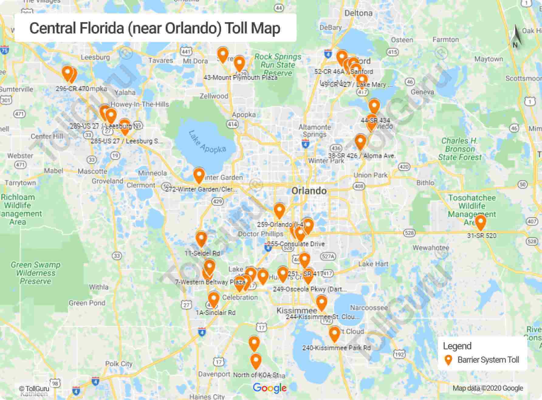
You'll come across the following eight stretches of toll roads in the Central Florida:
- Turnpike – Northern Coin System
- Martin Andersen Beachline West Expressway
- Seminole Expressway
- Southern Connector Extension
- Daniel Webster Western Beltway, Part C
- Wekiva Parkway
- Osceola Parkway / CR 522
- Poinciana Parkway
Use Orlando Toll Calculator to calculate toll and gas costs to travel across Central Florida and other toll facilities of Florida.
How do I pay Central Florida tolls
main article: How to Pay Toll in Florida
For all the toll roads under Central Florida Expressway Authority (CFX)[1], you can pay Central Florida tolls with:
- E-Pass (also have access to Reload lanes)
- SunPass
- E-ZPass
- Cash
- Pay By Plate
- PayTollo app
Visit the CFXWay website's Payment Option page[2] for detials on how these methods work and which facility accept them.
How much is FL 417 toll
FL 417 is the popular name for SR 417 or Central Florida GreeneWay in Florida. This 54-mile road is a tolled limited-access state highway maintained by both Central Florida Expressway Authority (CFX) and Florida's Turnpike Enterprise.
| Mainline Toll Plaza | E-Pass | Cash | Pay By Plate |
|---|---|---|---|
| John Young | $1.47 | $1.75 | $2.94 |
| Boggy Creek | $1.47 | $1.75 | $2.94 |
| Curry Ford | $0.88 | $1.00 | $1.76 |
| University | $0.88 | $1.00 | $1.76 |
You can use Florida Toll Calculator to calculate tolls and gas costs to travel across FL 417 and other toll facilities of Florida.
Florida Turnpike - Northern Coin System
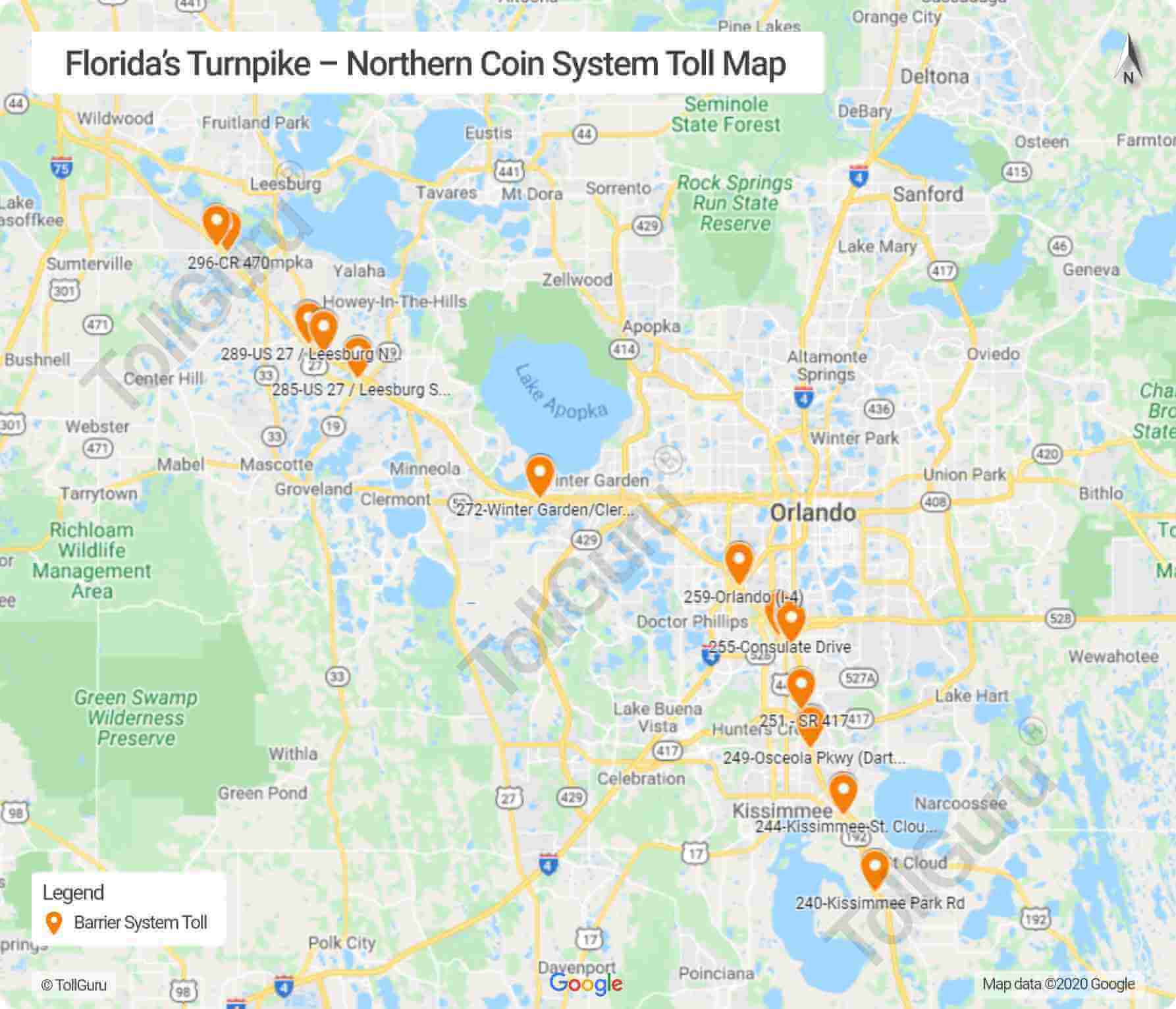
The Florida Turnpike is a north-south toll road operated by Florida’s Turnpike Enterprise[3] and includes the I-4, I-75 and I-95. The exits on these turnpike roads provide easy access to major state roadways. Read more about the highway connections on the Florida Turnpike website [4]. Tolls could be paid by cash, toll-by-plate, SunPass or other valid toll tags.
Martin Andersen Beachline Expressway
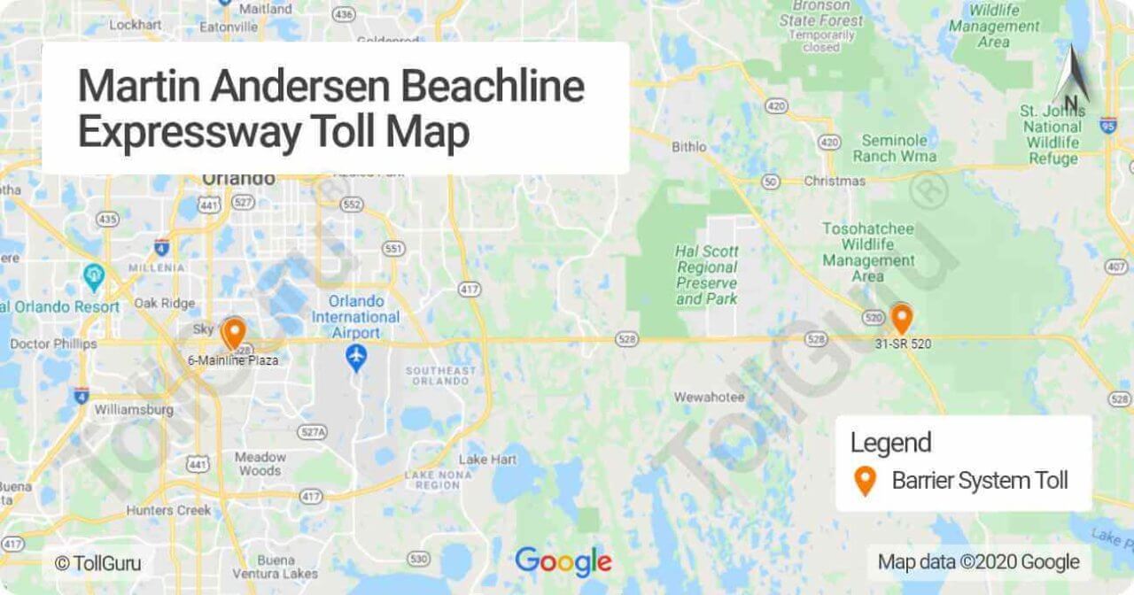
Martin Andersen Beachline West Expressway
The Martin Anderson Beachline Expressway or State Road 528 is an important connection to the Orlando International Airport, the east coast beaches and Cape Canaveral. The Beachline is owned and maintained by three agencies. The Martin Andersen Beachline West Expressway is operated by Florida’s Turnpike Enterprise. This is the westernmost eight miles that run as the Beachline Expressway West.
Martin Andersen Beachline East Expressway
Running as the State Road 528, the Martin Anderson Beachline Expressway also connects the John F. Kennedy Space Center and the aerospace industry with greater Orlando. It extends east from Interstate-4 across State Road 417 and Interstate 95, ending at U.S. Highway 1 in Cocoa. Martin Andersen Beachline East Expressway is operated by the Florida Department of Transportation. It is nine miles east of State Road 520 to the Bennett Causeway at US 1.
Seminole Expressway
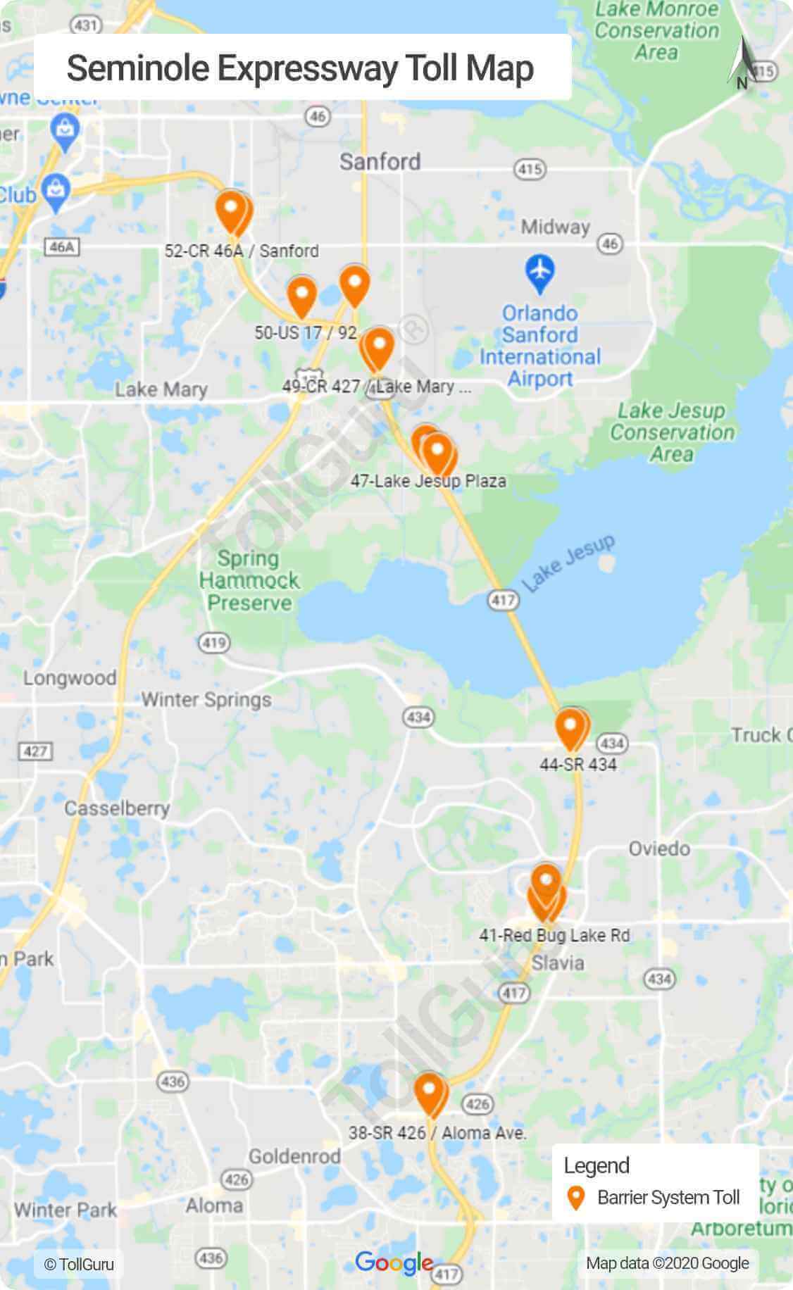
The Seminole Expressway is State Road 417 is a 55-mile toll road operated by CFX and Florida’s Turnpike Enterprise in the Orlando region that runs from north to south. It extends from the Seminole County line to Interstate 4 in Sandford.
Southern Connector Extension
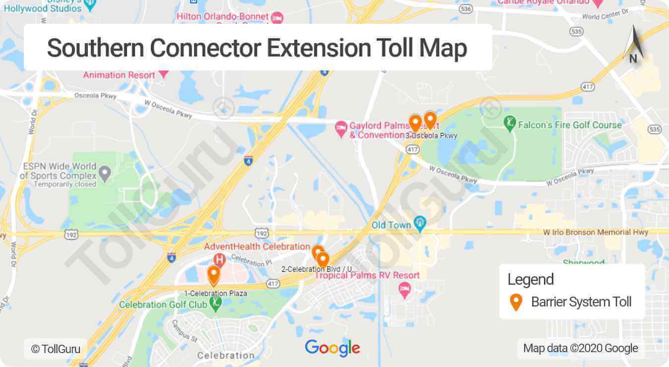
The Southern Connector Extension of the Central Florida GreeneWay is a section of State Road 417. It is also referred to as the southern end of the Central Florida GreeneWay. It forms the eastern belt around the city of Orlando. So although it runs north-south throughout its route; it also runs east-east between Celebration and Country Road 15. After Country road 15, it runs north-south through the rest of its route.
Daniel Webster Western Beltway - Part C
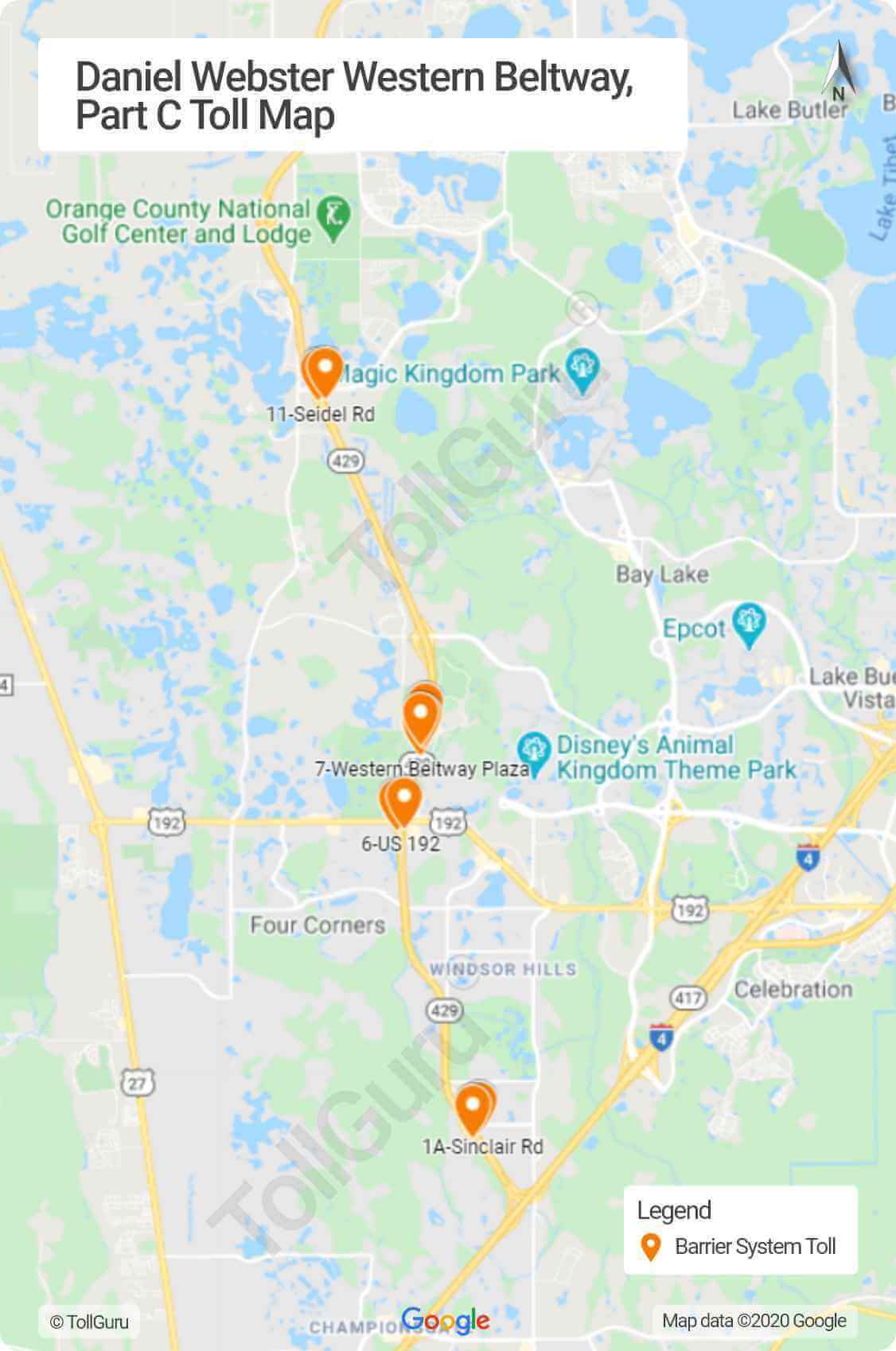
Daniel Webster Western Beltway or otherwise the State Road 429 extends from Highway 441 in Apopka south to Interstate 4 in Osceola County. It provides West Orange and Osceola counties with an alternate route, instead of the otherwise heavily travelled Interstate-4.
Wekiva Parkway
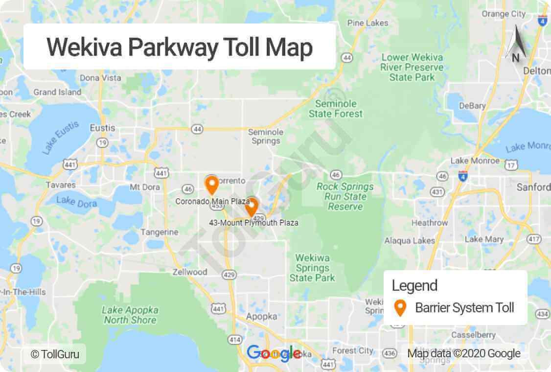
The Wekiva Parkway is a five-section parkway that is being constructed by the Central Florida Expressway Authority (CFX)[5] and is expected to be ready by 2023. The parkway is a 2-mile expressway and serves as an extension to State Road 429 (Daniel Webster Western Beltway). Beginning at SR 429 and SR 414 interchange at US 441 in Apopka, it will go north and then east along the SR 46 alignment in east Lake County and a portion of Seminole County before dipping south to connect to State Road 417 and Interstate-4 in Sanford. It is the final link in the Central Florida Beltway encircling Metro Orlando. The Parkway would be electronically tolled.
Osceola Parkway
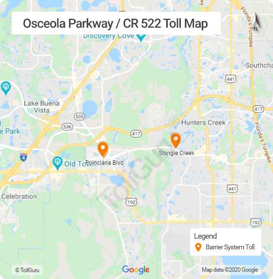
The Osceola Parkway / CR 522 [6] connects the Disney World resort area, near Kissimmee and Buena Ventura. The Parkway is a controlled-access toll road and serves as an important arterial connection across northern Osceola County and southern Orange County. The toll section of the Osceola Parkway runs between Seralago Boulevard, east of the exchange with State Road 417 (Central Florida GreeneWay), and Flora Boulevard, north of Kissimmee. Osceola Parkway Tolls are managed through the Central Florida Expressway Authority (CFX) [7]
Poinciana Parkway
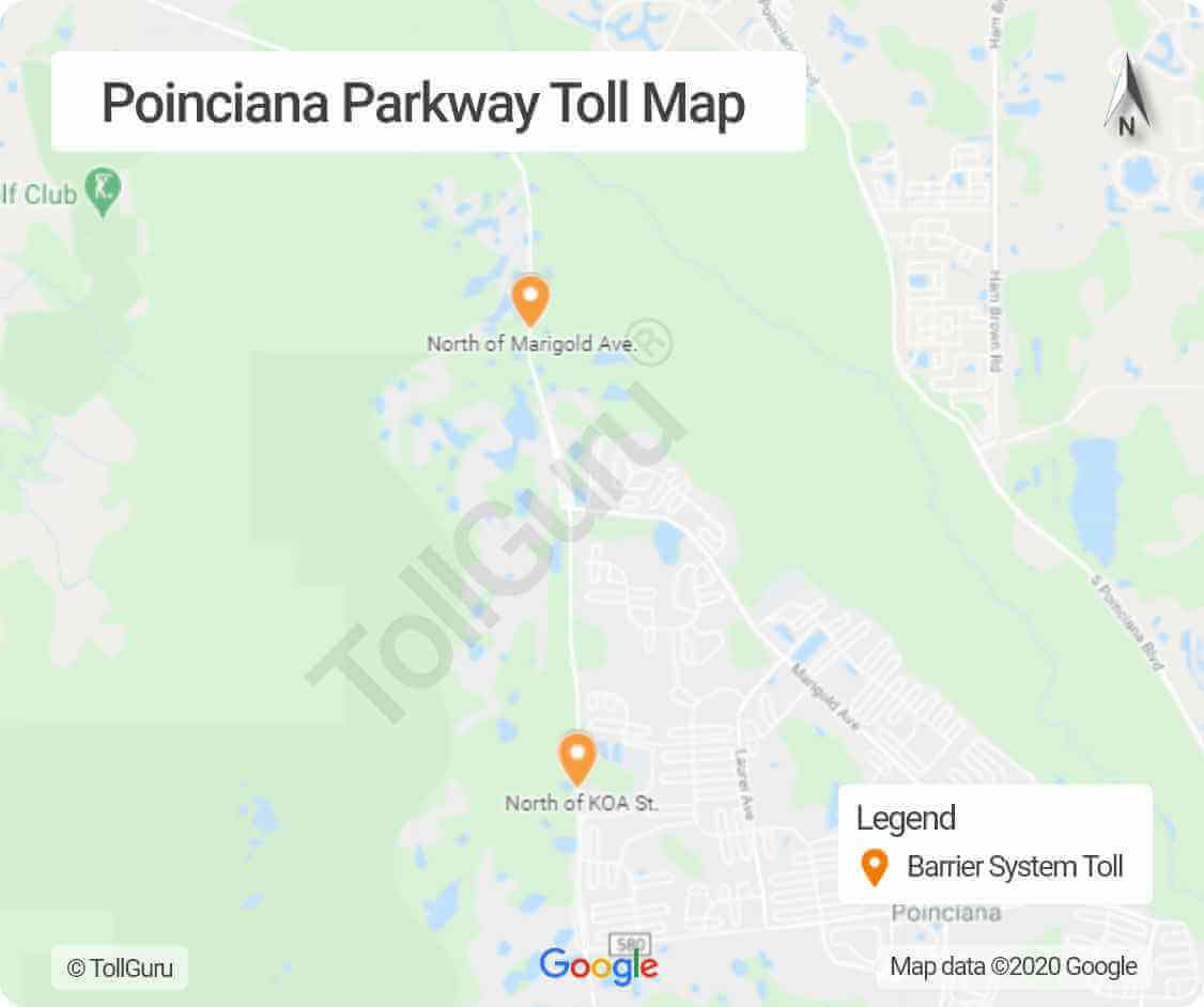
The Poinciana Parkway [8] or State Road 538 is a 7.2 mile toll road that extends from US 17-92 and Kinny Harmon Road all the way through Osceola County. Cypress Parkway eventually connects with Polk County. The Parkway is a vital north-south connection to theme parks and the metro Orlando area.
Detailed information on each toll road of the West Central Florida near Tampa can be found at Florida's Turnpike System [9].
Calculate tolls for Central Florida and other regions in the US
Calculate routes, tolls and fuel costs for your travel by car, truck, taxi, bus, caravans (with or without a trailer) in Central Florida and other regions of the US using TollGuru Trip Calculator - for free! It also shows the cheapest, fastest and other optimal routes to your destination along with toll plaza(s) location enroute, payment methods and more.
Rideshare, OEM, TMS, fleet companies and other transport businesses can leverage toll intelligence by integrating with the TollGuru Toll API for pre-trip calculation and post-trip reconciliation.
